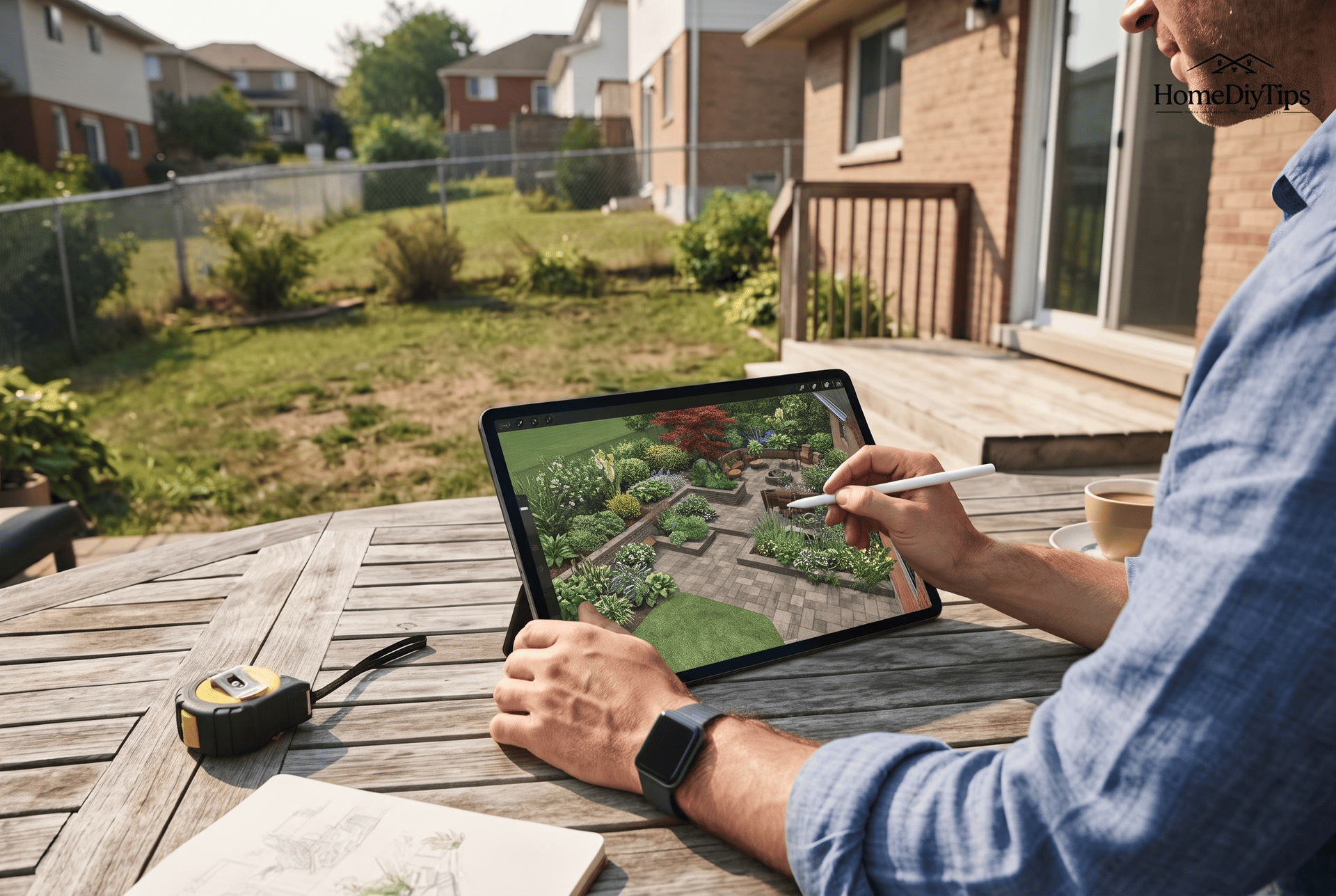
Planning a new garden, patio, or backyard can be difficult when you are working from a flat sketch or trying to picture changes in your head. 3D landscaping lets you build a digital view of an outdoor space so you can test layouts, plants, materials, and features before you buy or build. You can use a simple online planner for a small project or a more advanced program for detailed designs.
A 3D image is a planning aid, not proof that a design will work on your property. You still need correct measurements and checks for drainage, plant needs, underground utilities, and local rules. The right tool helps you make clearer choices, but it does not replace those real-world checks.
Direct Answer
3D landscaping creates a digital three-dimensional view of an outdoor space, helping you compare plants, paths, patios, and materials before work begins. It does not replace accurate measurements or site checks.
Experience
A layout can look roomy on screen but feel crowded when you add real furniture and mature plants. Check actual measurements, walking space, and plant sizes before buying materials or starting work.
What Is 3D Landscaping?
3D landscaping creates a three-dimensional digital model of an outdoor area. You can view a yard from different angles and see how paths, planting beds, patios, decks, fences, and walls may look together.
Most programs use libraries of plants, paving, furniture, and outdoor structures. You can move items, change materials, and compare layouts. Some also offer a virtual walkthrough.
A useful plan answers practical questions before work begins: Is there room for a table? Does a path reach the gate? Will a tree block a window?
2D Plans, 3D Models, and Photo-Based Designs
These methods do different jobs:
- 2D plan: A flat, top-down drawing of measurements, boundaries, paths, beds, and structures.
- 3D model: A view with height and depth. You can inspect a patio, tree, fence, or deck from different angles.
- Photo-based design: A picture of your actual yard with proposed plants, paving, or features placed over it.
Some programs combine all three. PRO Landscape+ offers photo imaging, scaled CAD drawings, and 3D renderings. VizTerra links 2D and interactive 3D views in one project. These are product-specific features, not standard in every free planner.
PRO Landscape++1
What Can You Design With 3D Landscaping?
A 3D design can help with front yards, backyards, gardens, patios, decks, and balconies. Choose ideas based on how you use the space and how much care it will need.
Front Yards, Backyards, and Gardens
For a front yard, compare a straight path with a curved one or test whether shrubs will hide windows. In a backyard, imagine placing a dining patio, a play lawn, and a garden bed. A 3D view can help you see whether these zones connect without blocking the main route.
Garden layouts might include raised vegetable beds, flower borders, shade trees, seating, gravel paths, stepping stones, or privacy screens. Check the mature width of trees and shrubs. A small symbol may grow into a plant that crowds a path or window.
Patios, Decks, Balconies, and Small Outdoor Spaces
Compact spaces benefit from trying furniture and containers before buying them. Test chairs, planters, storage benches, and screens, then check the layout from eye level as well as above. Keep routes clear around doors, steps, and gates.
Renters can plan movable pots, rugs, and freestanding furniture. Get permission before digging, adding permanent paving, attaching fixtures, or changing drainage.
Which Features Make a 3D Landscape Plan Useful?
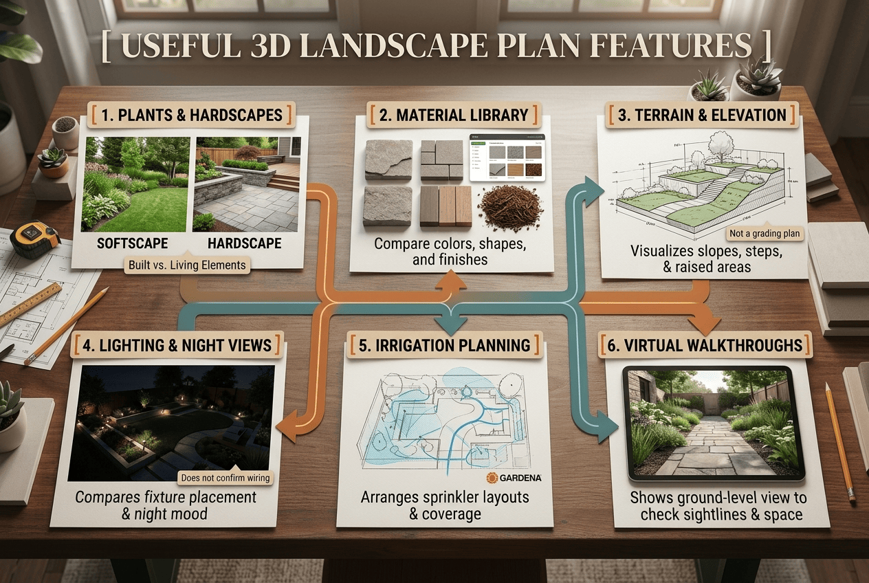
A program does not need every advanced feature to help with a small project. Choose features that answer the questions you actually have.
Plants, Hardscapes, and Material Choices
Landscape design includes two broad groups of elements:
- Softscape means living features such as grass, trees, shrubs, flowers, and other plants.
- Hardscape means built or nonliving features such as patios, pavers, retaining walls, decks, fences, and stone paths.
A plant library makes it easier to compare colors, shapes, and planting arrangements. A material library lets you test different paving, mulch, stone, or deck finishes. These previews help you compare the overall look, but screen colors and sample textures may not match the real products exactly.
Look for clear information about the objects in the library. A plant symbol should ideally identify the plant or give its expected dimensions. A generic green shape may help with rough layout, but it cannot tell you whether a plant suits your soil, sunlight, rainfall, or winter temperatures.
Terrain, Lighting, Irrigation, and Walkthroughs
Some tools let you add slopes, raised areas, steps, or different elevations. These features help you explain the shape of a project, but a visual slope is not a grading plan. A real site may need a survey or professional review before you change ground levels.
Lighting tools can show where fixtures might go and how a space could look at night. They are useful for comparing the mood and position of lights. They do not confirm electrical loads, wiring routes, or safe installation.
Irrigation features vary. Some landscape programs can show sprinkler symbols or draw an irrigation layout. A dedicated planner may help you select products and arrange coverage.
GARDENA’s free online my Garden planner, for example, includes a sprinkler-system planning tool and can produce a planning sketch and shopping list. That makes it useful for a GARDENA-based watering plan, but it is not a substitute for checking water pressure, flow, local rules, and the needs of your actual plants.
GARDENA+1
A virtual walkthrough is another helpful feature. It lets you look at the design from ground level instead of relying only on a top-down plan. Use it to check sightlines, seating space, and the feel of a path. Do not assume a realistic walkthrough confirms construction details.
How to Choose 3D Landscaping Software
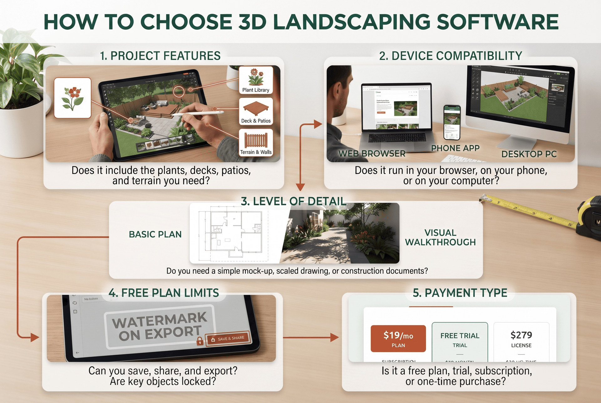
Start with the project. A flower bed may need only a basic planner, while a backyard with a deck, wall, and outdoor kitchen may need more detailed tools.
Before paying, check five things:
- Project features: Does it include the plants, decks, patios, fences, or terrain you need?
- Device: Does it run in your browser, on your phone, or on your computer?
- Level of detail: Do you need a visual mock-up, scaled drawing, or construction documents?
- Free-plan limits: Can you save, share, and export? Are key objects locked?
- Payment type: Is it a free plan, trial, monthly or yearly subscription, or one-time purchase?
Free Online and Beginner-Friendly Tools
Planner 5D offers a free online landscape design tool for 2D and 3D layouts of yards, patios, decks, paths, pools, and other outdoor features. Its site describes drag-and-drop editing, scale tools, and outdoor objects.
The general Free plan costs $0. Published US Premium pricing is $19.99 per month or $59.99 billed annually. Check which landscape objects and rendering features are available in the plan before starting a large design.
You can explore the Planner 5D landscape design tool and its pricing page.
Create 2D and 3D Outdoor Plans+1
SketchUp Free is a browser-based 3D modeler rather than a dedicated garden planner. It can suit someone who wants to build custom shapes or place models from its 3D Warehouse. It takes more practice than a simple drag-and-drop garden tool, and SketchUp says its Free version is for personal, noncommercial use. Its free users also do not receive standard SketchUp support.
See the official SketchUp Free guide before using it for a project.
help.sketchup.com+1
iScape is aimed at photo-based outdoor planning. Its pricing page lists a $0 limited download and trial option. Its Pro plan is $29.99 per month or $299.99 per year. The page states that its 2D and 3D design features are iOS-only, so check device compatibility before relying on it.
See the iScape pricing page for its current access options.
iScape
Desktop and Professional Landscape Design Software
Realtime Landscaping offers several Windows desktop versions. Its 2026 product pages list:
|
Version |
Published price |
|
Realtime Landscaping Plus |
$149 |
|
Realtime Landscaping Pro |
$279 |
|
Realtime Landscaping Architect |
$599 |
The company describes these as one-time licenses rather than monthly subscriptions, with optional future upgrades. Plus is positioned for visualizing yards and gardens; Pro adds broader design features; Architect is aimed at professional plans and presentations.
Plus and Pro include plant libraries and growth tools that can help users consider how gardens may develop over time. Compare the versions before paying, because the highest-priced option may include more detail than a homeowner needs.
Free Trial+3
VizTerra is a professional tool for landscapes, hardscapes, decks, and outdoor living areas. Its official pricing page currently displays $97 per user per month for monthly billing or $84 per user per month with annual membership. It runs only on compatible Windows PCs, so check the system requirements before starting a trial.
For a small personal project, its cost and professional focus may be more than you need. You can review its official features and pricing.
Structure Studios+2
PRO Landscape+ combines photo imaging, scaled CAD drawings, 3D renderings, lighting design, and a companion app for tablets. It is worth reviewing if you need both visual presentations and more detailed plan drawings. The provider does not display a simple public purchase price on its main software page, so request current pricing rather than relying on an old estimate.
PRO Landscape+
A published Capterra review offers another useful perspective. Landscape designer Susan T. praised the software’s ability to show clients how a landscape might look, but also reported glitches and a Favorites-folder problem after an update. This is one user’s experience, not a general performance test. Read Susan T.’s review and consider testing software with a small project before committing.
Capterra
Prices and plan limits can change. The prices above are vendor-listed US figures checked on November 12, 2026. Confirm the billing period, renewal price, trial terms, taxes, and included features at checkout. Also check whether a trial adds a watermark or limits the number of plants, objects, or exports.
How to Create a 3D Landscape Plan Step by Step
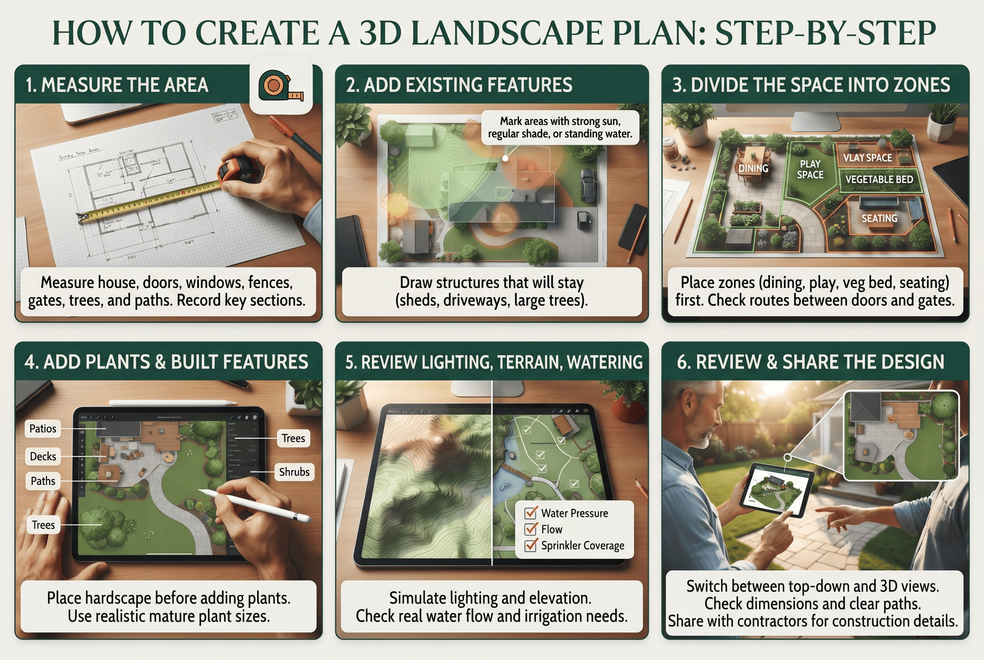
Start with a measured base. Add detail only after the main layout is correct.
1. Measure the Outdoor Area
Measure the space and note the house, doors, windows, fences, gates, trees, and paths. For an unusual shape, record each section instead of guessing.
Use a survey or qualified help when exact property boundaries matter. A rough sketch is useful for early ideas, but it is not a legal property survey.
2. Add Existing Features
Draw structures that will stay, such as a shed, driveway, steps, or large tree. Mark areas with strong sun, regular shade, or standing water. This creates a more realistic base plan.
3. Divide the Space Into Zones
Decide whether you need dining, play space, a vegetable bed, or a quiet seating area. Place the zones first, then check the routes between doors, gates, storage, and seating.
4. Add Plants and Built Features
Place patios, decks, paths, walls, and fences before adding trees, shrubs, flowers, lawn, and containers. Use realistic mature plant sizes.
Save different versions so you can compare a tree’s position or a patio’s shape. This makes it easier to review changes without losing an earlier layout.
5. Review Lighting, Terrain, and Watering
Use available tools to show lighting and elevation, but note real water flow after rain. For irrigation, check water pressure, flow, sprinkler coverage, and local requirements before buying or installing a system.
6. Review and Share the Design
Switch between top-down and 3D views. Check dimensions, clear paths, seating, and plant space.
Share the plan with household members or a contractor. They may still need material specifications, drainage details, or separate construction drawings. A 3D view can make a conversation easier, but it does not automatically provide every document needed to build the project.
What Should You Check Before Turning a 3D Design Into a Real Project?
The final model should help you ask better questions about the site. It cannot answer every question by itself.
Measurements, Slope, and Drainage
Check the actual height and direction of slopes before adding steps, walls, or raised beds. Water should not be directed toward a house, foundation, or neighboring property. A model may show a slope, but it cannot test how soil absorbs water or how runoff behaves during a heavy storm.
Rain gardens are one example where site conditions matter. The EPA’s rain garden guidance explains that placement, soil infiltration, nearby utilities, and the risk of water entering basements or crawlspaces all need attention.
The guide is written for semi-arid conditions, so use local guidance for your area rather than copying its technical details as a universal rule.
Rain gardens
If your yard already has standing water, erosion, a steep slope, or water near the foundation, do not rely on a rendering to solve it. Ask a qualified local drainage or landscape professional to assess the site before changing grades or installing drainage features.
Plant Size, Climate, and Growing Conditions
Choose plants for the place where they will grow, not only for how they look in the software. Check mature height and width, sunlight needs, soil, water needs, and maintenance. A plant that looks good in a model may struggle in heavy shade or dry soil.
For US perennial plant choices, the USDA Plant Hardiness Zone Map is a useful starting point. It is based on average annual extreme minimum winter temperatures. It does not tell you everything about a plant’s needs, such as summer heat, humidity, soil type, or rainfall, so combine it with local nursery or university extension guidance.
USDA Plant Hardiness Zone Map+1
Underground Utilities, Permissions, and Professional Plans
Before you dig for trees, posts, fences, irrigation, or planting beds, contact 811 or the relevant one-call service in your state and follow its timing instructions. Requirements differ by location.
For example, Texas811 tells homeowners to give two business days’ notice before digging in Texas. Some privately installed lines may not be covered by the public utility marking service, so ask whether a private locator is needed. See the Texas811 homeowner guide.
Texas811
Renters should get permission before making permanent changes. Check lease terms and property rules before digging, attaching lights or screens, changing paving, or altering drainage.
A 3D design may be enough to discuss an idea, but a construction project can require scaled drawings, material specifications, drainage details, permits, or structural plans. Some professional software can produce dimensioned plans from the same project file; a simple visual planner may not. Ask the contractor or local authority what documents are needed before work starts.
Structure Studios+1
Common 3D Landscaping Mistakes to Avoid
- Guessing measurements: A patio may look large enough on screen but leave too little space for chairs or a walkway.
- Using small plant symbols: Check mature plant size, not just the size of the picture in the library.
- Ignoring shade: Consider how existing buildings and trees affect light during the day.
- Forgetting drainage: Do not add a low area or rain garden without checking the soil and water flow.
- Trusting a material preview too much: View real samples when color, texture, or surface feel matters.
- Buying software too early: Try the free plan or trial with a small sample project first.
- Treating a rendering as a build plan: Confirm dimensions and technical details separately.
A useful design should solve practical problems, not just look attractive from one camera angle.
Frequently Asked Questions About 3D Landscaping
Can I design my landscape in 3D for free?
Yes. Planner 5D offers a free landscape design option, while GARDENA my garden is a free online garden and sprinkler planner. Their features differ, so check the tools and export options before starting.
What is the easiest 3D landscaping software for beginners?
It depends on your device and project. Try a small sample in an online planner or photo-based app before paying. Check how easily you can measure, add objects, and save the design.
Can I design my yard using a photograph?
Yes. Photo-based tools place proposed plants or materials over a picture of your yard. This helps compare styles, but does not automatically create accurate measurements or construction drawings.
Does landscape design software show plants at their mature size?
Some programs include plant-growth information, but not all do. Confirm mature size with a reliable plant reference and check local growing conditions.
Can 3D landscaping software help plan irrigation?
Some do. GARDENA my Garden includes a sprinkler planner for its system. Check water flow, pressure, coverage, and product compatibility before installation.
Start With a Measured Outdoor Design
You do not need expensive software to begin planning an outdoor space. Choose a tool that fits your project, measure the area, and test one simple layout before adding every plant and feature. Then check the design against real site conditions. A clear 3D plan can help you make better choices, but accurate measurements and local advice are what turn a good idea into a workable project.
Disclaimer
Homes, budgets, site conditions, and project needs vary, so check product details and local rules before making changes. Seek qualified local help for significant grading or drainage, structural work, electrical installations, excavation concerns, or projects requiring permits.